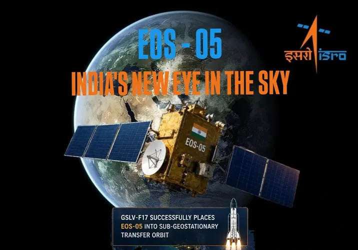

India’s space programme has entered another interesting phase with the successful deployment of EOS-05 aboard GSLV-F17 on August 29, 2026. The mission is significant not simply because another satellite has been placed in orbit, but because it takes Earth imaging into a geosynchronous orbit, giving India a different way to observe large areas of the planet.
The successful mission adds a new dimension to India’s Earth-observation capabilities. While satellites in lower orbits are highly useful for detailed imaging, a geosynchronous platform can offer a broader and more persistent view. That difference could prove valuable for monitoring rapidly changing situations such as extreme weather, disasters and large-scale environmental developments.
EOS-05: India’s New Eye in the Sky
EOS-05 is a state-of-the-art Earth-observation spacecraft developed as part of India’s expanding satellite capabilities. Its primary application is Earth observation, but its importance comes from the unusual orbital position chosen for an imaging satellite. The spacecraft is India’s first-ever imaging satellite from a geosynchronous orbit, marking a notable shift in the way the country can approach satellite-based observation.
Earth-observation satellites are used to collect information about the surface and atmosphere for a wide range of purposes. They can help track changes in land, water bodies, vegetation and infrastructure, while also supporting responses to natural disasters. What makes EOS-05 particularly interesting is that its orbital environment offers a different perspective from the lower-altitude satellites that have traditionally carried out much of this work.
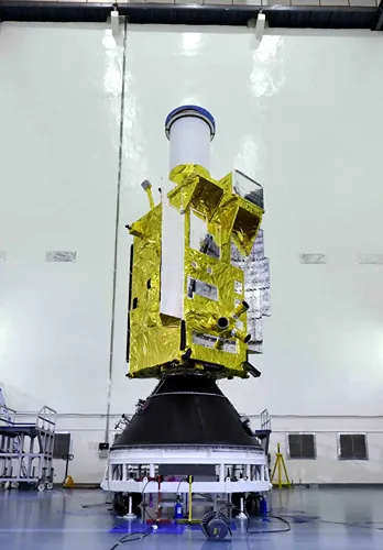
Photo: Indian Space Research Organisation
The basic idea is straightforward. Instead of relying only on satellites that move quickly across the planet and return to the same area at intervals, a geosynchronous imaging spacecraft can maintain a much more consistent relationship with a particular region of Earth. This creates opportunities for repeated observations over broad areas and could be especially useful when conditions on the ground are changing rapidly.
EOS-05 mission at a glance
| Mission detail | Information |
|---|---|
| Satellite | EOS-05 |
| Satellite type | Earth Observation |
| Primary application | Earth observation |
| Launch vehicle | GSLV-F17 |
| Launch date | 29 August 2026 |
| GSLV flight | 19th flight |
| Launch site | Second Launch Pad, Satish Dhawan Space Centre |
| Initial orbit | Sub-Geosynchronous Transfer Orbit |
| Distinctive feature | India’s first imaging satellite from geosynchronous orbit |
| Payload fairing | 4-metre-diameter ogive composite version |
GSLV-F17 Successfully Deploys EOS-05
The EOS-05 mission was carried out using GSLV-F17, the 19th flight of India’s Geosynchronous Satellite Launch Vehicle. The launch took place from the Second Launch Pad at Satish Dhawan Space Centre, SHAR, on August 29, 2026. The mission used the 4-metre-diameter ogive composite version of the GSLV payload fairing.
The vehicle successfully placed EOS-05 into its intended Sub-Geosynchronous Transfer Orbit, or Sub-GTO. Reaching this orbit is an important stage in the mission because the spacecraft can subsequently be manoeuvred towards its operational orbital position. The deployment therefore represents more than the successful separation of a satellite from its launcher. It demonstrates the GSLV’s role in placing increasingly specialised spacecraft into demanding orbital regimes.
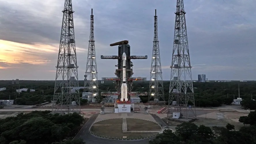
Photo: Indian Space Research Organisation
For ISRO, the mission also adds another achievement to the GSLV programme. The launch vehicle was originally developed to handle heavier payloads and missions requiring higher-energy orbits. Its continued use for sophisticated missions such as EOS-05 reflects the importance of having a domestically developed launch capability capable of supporting different categories of Indian satellites.
The mission also highlights an important feature of modern space programmes. Building a satellite is only one part of the challenge. The launch vehicle, orbital insertion, spacecraft systems and eventual operational positioning all have to work together. The successful deployment of EOS-05 shows the importance of this complete chain in India’s growing space infrastructure.
Why EOS-05’s Geosynchronous Orbit Is Significant
The most distinctive feature of EOS-05 is its use of a geosynchronous orbit for imaging. A geosynchronous satellite travels around Earth at an orbital period that matches the planet’s rotation. When the orbit is appropriately aligned, the satellite can appear to remain over roughly the same region from the perspective of an observer on Earth. This is particularly useful for applications that require frequent observation of a large area.
Most Earth-observation satellites operate much closer to Earth. Their lower orbits allow them to capture highly detailed images and are well suited to applications where resolution is the priority. However, these spacecraft continuously move across the planet. A geosynchronous imaging satellite approaches the problem differently, offering a broader and more persistent field of observation.
That distinction gives EOS-05 a potentially valuable role in monitoring large-scale developments. Weather systems, floods, fires, coastal changes and other events can develop quickly. Having an imaging platform positioned to repeatedly observe a broad region can help build a more continuous picture of how such events evolve. It does not replace lower-orbit satellites, but complements them by providing a different type of observation.
For India, the geographical scale is particularly relevant. The country experiences cyclones along its coastlines, floods across river basins, landslides in mountainous regions and significant variations in agricultural and environmental conditions. A satellite capable of repeatedly observing large areas could provide another layer of information for agencies responsible for monitoring and responding to such events.
What EOS-05 Can Do for India
The practical value of EOS-05 will ultimately depend on the quality of the imagery it produces and how effectively that information is integrated into operational systems. Earth observation has become increasingly important because satellite imagery can provide a view that is difficult to obtain from the ground alone. Large territories can be monitored without having to physically access every location.
The potential applications span civilian, environmental and strategic requirements. The ability to repeatedly observe broad areas can be particularly useful when authorities need to understand how a situation is developing rather than simply obtaining a snapshot at one point in time.
- Disaster management: Repeated observations can support monitoring of floods, cyclones, fires and other large-scale emergencies.
- Agriculture: Satellite observations can contribute to assessing vegetation, crop conditions and changes in agricultural land.
- Water resources: Changes in reservoirs, rivers, wetlands and other water bodies can be monitored over time.
- Environmental monitoring: Large-scale changes in forests, coastlines and land use can be studied using satellite data.
- Infrastructure planning: Earth-observation data can assist in mapping and monitoring expanding urban and infrastructure networks.
- Strategic applications: High-value satellite imagery can provide useful information for monitoring sensitive geographical areas and developments.
One of the biggest advantages is the possibility of combining information from different types of satellites. A lower-orbit Earth-observation spacecraft can provide detailed imagery of a particular location, while EOS-05 can offer broader and more frequent observation. Together, such systems can create a more complete picture than either type of satellite could provide on its own.
This is where the mission becomes particularly relevant to disaster management. During a cyclone or major flood, conditions can change within hours. Roads can become inaccessible, river levels can rise and affected settlements can expand rapidly. Satellite-based observation cannot solve these problems by itself, but timely imagery can help authorities understand the scale and direction of a developing situation.
EOS-05 Opens a New Chapter for India’s Space Ambitions
The successful deployment of EOS-05 is part of a broader evolution in India’s space programme. India has spent decades building Earth-observation capabilities for agriculture, mapping, weather-related applications, natural-resource management and disaster response. The move towards more specialised orbital platforms shows how these capabilities are becoming increasingly sophisticated.
The significance of EOS-05 therefore lies not only in the satellite itself but in the capability it adds to the wider system. Geosynchronous imaging offers a different operational perspective from conventional Earth-observation missions. It can potentially provide persistent observation of broad areas while other satellites deliver higher-resolution views when required.
There is also a strategic dimension to this development. Space-based observation is becoming increasingly important for countries that need timely information about their territory, borders, maritime zones, infrastructure and environmental conditions. The ability to design, launch and operate specialised satellites domestically reduces dependence on external systems and gives India greater control over how space-based data is generated and used.
The GSLV-F17 mission also reinforces the role of India’s launch vehicles in this expanding ecosystem. With EOS-05 successfully placed into Sub-GTO, ISRO has demonstrated the ability to support a mission built around a distinctive orbital requirement. As India’s space ambitions continue to expand, the combination of stronger launch vehicles, sophisticated spacecraft and diverse orbital capabilities will become increasingly important.
EOS-05 is therefore more than another addition to India’s satellite fleet. It represents a new vantage point for Earth observation and expands the range of tools available to monitor a rapidly changing planet. Its real value will emerge through the data it provides and the decisions that data can support, but its successful deployment has already opened an important new chapter in India’s Earth-observation programme.
What is EOS-05?
EOS-05 is a state-of-the-art Indian Earth-observation satellite. It is notable for being India’s first-ever imaging satellite from a geosynchronous orbit.
When was EOS-05 launched?
EOS-05 was launched on 29 August 2026 aboard the GSLV-F17 from the Second Launch Pad at Satish Dhawan Space Centre, SHAR.
Which launch vehicle carried EOS-05?
The satellite was carried by GSLV-F17, the 19th flight of India’s Geosynchronous Satellite Launch Vehicle.
What orbit was EOS-05 initially placed into?
GSLV-F17 successfully placed EOS-05 into a Sub-Geosynchronous Transfer Orbit (Sub-GTO), from where the spacecraft can be moved towards its intended operational orbit.
Why is EOS-05 significant for India?
EOS-05 gives India a new Earth-observation capability from a geosynchronous orbit, with potential applications in disaster monitoring, agriculture, environmental observation, infrastructure planning and strategic surveillance.